Being up a hill should increase your low angle radiation. When you TX and RX radio waves what hits our antennas is a combination of direct sky wave and reflected ground waves. The sloping ground creates a favourable TX and RX in that direction. A lot of the DX from outside of Europe on 11m band (95pct) is coming in between 1 and 10 degrees off the horizon. Pretty low eh ? I was surprised to learn this as well.
The reason is that sloping ground makes the reflections more favourable at low angles. When there are 2 waves (one direct and one reflected combining together), in part they cancel each other and in part they reinforce each other. This is known as the phase of the waves. So the slope means there is greater reinforcement at lower angles than flat ground would allow.
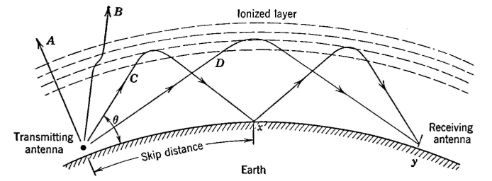
This following image shows a ground reflection but for a line of sight contact, not propagated by the ionosphere. However the principle is the rather the same.

Phase of 2 waves they either add or subtract at different points of the combining. These are just example phases.

Low angles generally create the longest possible DX paths (when those paths are open).
At the seaside you get about 9dB extra gain on your TX and RX in the sea's direction. This is because the salt water reduces the "ground" losses associated with the summed reflections on tx and rx. It also increases the strength of your low angle radiation. Some research has suggested that you do not even need to be right on the beach to get some benefits.Though this is more likely at lower frequencies (with longer wavelengths) Read the first paragraph for more information:
http://www.on5au.be/Cebik-2/ThePseudo-b ... isited.pdf
I know a couple of CBers (also hams) went to the seaside to activate a location for an event on 11m and I was on a hill, I could here them just about. Sadly for some reason they had a bad day DX and I was doing quite well on the hill... in the same hours.
Both will often have 1 single major advantage, low noise floor. You will hear so much more with a low noise floor.
This is worth a look:
Low incidence angles can travel longer distances, longest is about 2,500 miles per hop from what is known as the F2 layer.
And in the early morning (say between 7am and 11am when conditions allow) you can make long path contacts to Aus and New Zealand
using a slightly different propagation called Chordal hop. (this is only theorized) A type of propagation where your radio waves become trapped
in the upper atmosphere due to a expansion/distortion of the layers which allow the waves to becomes ducted in the F2 layer. This is normally associated with the grey line. The grey line is a line around the planet where the sun is rising and setting in a distant location. Unique properties
at this time allow such "chordal" contacts. Rather than come back down with multiple lossy bounces it remains in the layers of the atmosphere themselves.

Have a read here:
https://www.pa9x.com/long-path-or-short ... opagation/
CB'er s are amateur radio people as well. It is just you are not called amateurs.
Even if you don't want to be a ham you can still learn a lot and it will help your dx chances.